How to find a flood tide fishing spot
First and foremost, I don't want to take the excitement and adventure away from you and tell you where to go and when. Don't simply look for other boats on the water, either (you may not know why they are where they are). That said, I do want to share a few tools I find very helpful when I'm deciding when and where to find a flood tide.
Depending on who you ask, you'll hear these called flood tides, spring tides, or king tides. A purist will tell you "flood tide" technically means any incoming tide, "spring tide" is the moon-driven extreme around a full or new moon, and "king tide" is reserved for the biggest springs of the year. On the flats, we mean the same thing by all of them, enough water where there usually isn't any. Or, as folks around here put it: the sharks are in the collards.
Let's start with the basics. A flood tide is a magical window of time when a higher-than-average high tide gives redfish (and other species) access to a marsh flat that's usually out of the water. Different bottom, different grass, and, more importantly, crabs. That's what they're after.
With the 30-second flood-tide ecology crash course under your belt, let's talk physics. It's about the moon. The PhDs at NOAA do a good job of showing what causes different tides.
Some areas farther inland have wind-driven tides. If you're in one of those, I'm going to leave you to your own devices for now: consult a local guide. Wind-driven tides deserve their own conversation.
Practically speaking, the days around a full or new moon typically give you the most extreme tides, because the moon is pulling harder on the seas than normal, and the waxing gibbous nights building toward the full moon are often already good enough. You can see this in tidal coefficients, which measure the relative pull of the moon on the predicted tide: the higher the coefficient, the higher the tide. Roughly speaking, a coefficient of 80 or more is likely to produce a flood tide.
All that said, if you don't want to worry about your zodiac sign and the fish's zodiac sign, take a look at the calendar view in our app. You can set a high-water mark that flags only the highest tides at a particular station. Look at a month of high tides (June, say), find the highest peaks, and set the high-tide line just below them. Then look at when those "flood tides" happen. Fingers crossed it's in daylight (and light wind).
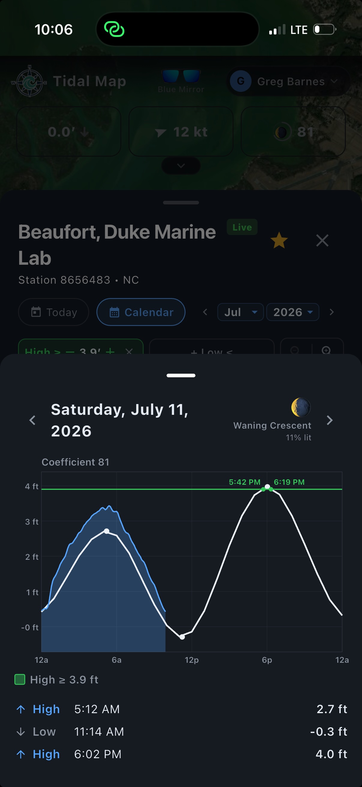
*A note on this one: I'd expect the upcoming tide to outperform the predicted water level, just like the morning high did: see how the actual water (the blue line) ran above the prediction (white). When the live water is already beating the forecast, the next high often does too.
You might say that's a lot of qualifiers. That tide, at that station. The tide is different at two different places at the same time. They often trend together, but depending on the area, two spots just a few miles apart can hit high tide an hour apart, and high tide at one spot might run inches, or feet, higher than the spot down the way. Yes, it's a lot when you write it down. But the tide is the key to everything.
So you've found a flat you want to explore from satellite images, and you know the rough two-hour window to fish a flood tide there, based on the nearest predicted-tide station. Those are predictions. On the day of, check a station reporting actual water levels. Sometimes the tide runs higher or lower than expected; sometimes wind makes it early or late. A live station near you shows how today's water compares to the prediction, then you use your best judgment about what that means for the water and timing where you're fishing. If high tide at the station nearest your flat runs 35 minutes behind a live station, that live reading is a pretty good preview of your near future. There are always caveats: if a station sits a quarter mile away but on the other side of an island, with the nearest inlet five miles off, don't rely on it alone.
Go explore. Reference the most relevant data for the spot you want to fish, then see what actually happens in real life. Use that experience to build new theories and game plans to test.
– Greg Barnes
P.S. This evening (July 11, 2026) is a flood tide on my favorite flat in coastal Carolina. Your flat is calling. You just need to explore.